|
|
|
Advertisements:
GeographyLocation
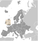
Westeuropa, Insel in der irischen See, zwischen Großbritannien und Irland Geographic coordinates
54 15 N, 4 30 W
Map references
Europa
Area
Total 572 sq km
Land 572 sq km Water 0 sq km Area - comparative
Etwas mehr als drei Mal so groß wie Washington, DC Land boundaries
0 km
Coastline
160 km
Maritime claims
Territorial sea 12 nm
Exclusive fishing zone 12 nm Climate
Gemäßigt; kühlen Sommern und milden Wintern; bedeckt etwa ein Drittel der Zeit Terrain
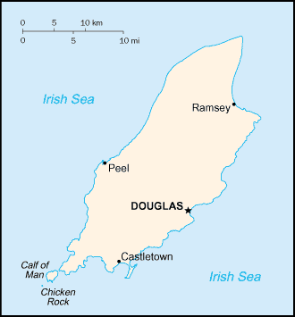
Hügel im Norden und Süden von Central Valley halbiert Elevation extremes
Lowest point Irish Sea 0 m
Highest point Snaefell 621 m Natural resources
None
Land use
Arable land 10%
Permanent crops 0% Other 90% (permanent pastures, forests, mountain, and heathland) (2002) Irrigated land
0 sq km
Natural hazards
NA
Environment - current issues
Abfallentsorgung (Haushalt und Industrie); grenzüberschreitende Luftverunreinigung Geography - note
Eine kleine Insel, die Calf of Man, liegt im Südwesten und ist ein Vogelschutzgebiet
Anmerkungen
Neue Anmerkung hinfugen: |
Advertisement
Login
Insel Man [ Germany ] (British Crown Dependency):
GPS-Punkte in Insel Man [ Germany ] (British Crown Dependency)
|
||||||||
 Teil des norwegischen Königreichs der Hebriden bis ins 13. Jahrhundert, als es nach Schottland, die Insel kam unter der britischen Krone im Jahre 1765 abgetreten wurde. Aktuelle Anliegen gehören die Wiederbelebung der fast ausgestorbene Manx-Gälisch. Isle Of Man ist eine britische Krone Abhängigkeit jedoch nicht Teil des Vereinigten Königreichs oder der Europäischen Union. Die britische Regierung bleibt jedoch für seine Verteidigung und internationale Vertretung verfassungsrechtlich verantwortlich.