|
|
|
Advertisements:
GeographyLocation
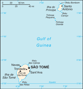
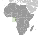
Zentralafrika, Inseln im Golf von Guinea, gebietsübergreifende den Äquator, westlich von Gabun Geographic coordinates
1 00 N, 7 00 E
Map references
Afrika
Area
Total 964 sq km
Land 964 sq km Water 0 sq km Area - comparative
Mehr als fünf Mal so groß wie Washington, DC Land boundaries
0 km
Coastline
209 km
Maritime claims
Gemessen von behauptete Archipelstaat Basislinien Territorial sea 12 nmExclusive economic zone 200 nm Climate
Tropischer; heiß und feucht; eine Regenzeit (Oktober bis Mai) Terrain
Vulkanische, bergig
Elevation extremes
Lowest point Atlantic Ocean 0 m
Highest point Pico de Sao Tome 2,024 m Natural resources
Fisch, Wasserkraft
Land use
Arable land 8.33%
Permanent crops 48.96% Other 42.71% (2005) Irrigated land
100 sq km (2003)
Natural hazards
NA
Environment - current issues
Entwaldung; Bodenerosion und Erschöpfung Environment - international agreements
Party to
Biologische Vielfalt, Klimawandel, Klima ändern-Kyoto Protokoll, Wüstenbildung, gefährdete Arten, ökologische Modifikation, Gesetz der Meer, Schutz der Ozonschicht, Schiff Verunreinigung, Feuchtgebiete Signed, but not ratified Keines der ausgewählten Abkommen Geography - note
Das kleinste Land in Afrika; die beiden Hauptinseln sind Teil einer Kette von erloschenen Vulkanen und beide sind gebirgig
Anmerkungen
Neue Anmerkung hinfugen: |
Advertisement
Login
Sao Tome Und Principe (Sao Tome):
GPS-Punkte in Sao Tome Und Principe (Sao Tome)
|
||||||||
 Entdeckt und behauptet, von Portugal im späten 15. Jahrhundert, der Inseln Zucker basierenden Wirtschaft Weg Kaffee und Kakao im 19. Jahrhundert - alle mit Plantage Slave Labor gewachsen gab verweilten eine Form davon ins 20. Jahrhundert. Während Unabhängigkeit 1975 erreicht wurde, wurden die demokratische Reformen nicht bis in die späten 1980er eingeleitet. Das Land hielt seine ersten freien Wahlen 1991, aber häufige internes Gerangel zwischen den verschiedenen politischen Parteien wiederholten Änderungen in der Führung und zwei gescheiterten Putsch in 1995 und 2003 ausgefällt. Die jüngste Entdeckung von Öl in den Golf von Guinea verspricht erhöhte Aufmerksamkeit auf die kleine Insel-Nation.